Our comprehensive story on the challenges Fraser Valley dairy farmers are facing
Our comprehensive story on the history of Sumas Prairie, Sumas Lake, and the Nooksack River
Our investigation into why the Sumas dike failed, and how the valley is unprepared for a Fraser flood
Our daily updates on the flood situation
This story was published at 6:30am Tuesday morning. For the latest Nooksack flood forecast, click here. The forecast is updated twice daily.
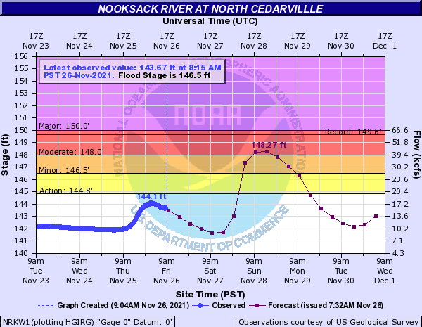
Update: Friday, 9:45am
The Nooksack didn’t rise as high as forecast Friday morning. But the forecast for the second wave has worsened considerably, potentially because snow that fell as rain overnight is expected to melt as temperatures increase..

Our in-depth story published Tuesday morning:
The Nooksack River might not be done with Sumas Prairie.
With heavy rain again forecast for the south coast, more eyes will be watching the Nooksack than there were a week ago, when the river took many Canadians by surprise.
The river is expected to crest again on Friday and, while forecast models are not yet predicting another flood of the Nooksack, one is still possible, with water levels forecast to come worryingly close to the top of the river’s banks. Two more atmospheric rivers—one on Thursday, another on Saturday— are expected to hit the Fraser Valley and dump as much as 70mm of rain on the region.
“I would just caution that we are dealing with very active weather for the foreseeable future,” Environment Canada meteorologist Armel Castellan told reporters Monday morning.
The Weather Network predicted Monday that some of the heaviest precipitation over the next week may be seen on the west side of Mt. Baker, where most of the Nooksack’s water comes from. Some of that is likely to fall as snow, but the temperature is forecast to increase during the weekend, likely causing much of the snow to melt. American river forecast models suggest there remains a significant potential for another Nooksack flood, whether it comes next week, next month, or early next year.
Lots of interest on the Nooksack River Basin, so let’s fly and check out projections this week through Friday AM #BCStorm #Nooksack pic.twitter.com/GokFoTZqNU
— Tyler Hamilton (@50ShadesofVan) November 23, 2021
Something we don’t need – an additional 20-40 cm of snowfall in the Nooksack Basin, that will subsequently melt.. #BCStorm pic.twitter.com/FuBHYpPaKm
— Tyler Hamilton (@50ShadesofVan) November 23, 2021
Leaving the Nooksack aside for a moment, the rain is expected to exacerbate problems in already-swollen rivers and saturated fields. Over the last couple days, Sumas Prairie farmers have reported a drop in the level of water in the former bed of Sumas Lake. But there is still a lot of water left to pump out of the area and the rain will slow the recovery. The Barrowtown Pump Station can pump 500,000 gallons per minute, and 70mm of rain will amount to hundreds of millions of gallons that must be extracted from the prairie. (100mm of rain over a 50-square-km area amounts to a little more than one billion gallons.)
Meanwhile, crews are working to shore up the dike in the valley as quickly as possible. And time is of the essence because water from the Nooksack could return to Canada , if not in the next week, then in the coming months.
River forecasters with the US Weather Service expect the Nooksack to peak mid-day on Friday. The good news: they say a flood is, at this point, not probable. The bad news: it is very possible, and growing more likely.
The forecasting models suggest that the river will likely rise as the result of rain, and near the top of its banks on Friday. Flood stage is at 146.5 feet at North Cedarville, where the river exits the foothills of Mt. Baker south of Everson. On Monday morning, the model predicted water would peak at around 143 feet. At 2pm, the forecast was updated, with the peak predicted to exceed 145 feet. But those predictions come with a sizeable margin of error. And the river is expected to rise again toward the 145 feet level on Sunday.

There is still a lot of time for those predictions to change as Friday approaches.
As of mid-day Monday (before the latest projection), the Nooksack River forecast suggests there is a one-in-10 chance of minor flooding on Friday and around a 5% chance of moderate flooding. With the ground already soaked, more of any flood water could make its way north of the border compared to a typical year. A forecast by the US National Weather Service suggests the Nooksack could swell even further by the following Wednesday.
Long-term, the prognosis is just as concerning, if not more so.

A conditional simulation of flood possibilities suggests there may be a one-in-three chance of moderate flooding. (That’s like successfully rolling a five or a six with a single die roll.) There is a one-in-10 chance that floodwaters will near “major flood” territory. It is important to recognize that such a flood is still less likely to not happen than to occur. But the odds are concerning, particularly given the state of the Sumas dike, the Sumas Lake bed, and recovery efforts that, in many cases, haven’t even begun yet.
Then there is the prospect of a minor flood of the Nooksack. Such a spillage does not normally pose problems for Canada, but the saturation of the ground could change that. The American model suggests there is as much as a 60% chance of that occurring.
We will closely monitor the situation, and provide regular updates on the Nooksack flood forecast and probabilities on our regularly updated story here.


